A New Era of Texas Flood Preparedness With Statewide Base Level Engineering (BLE)
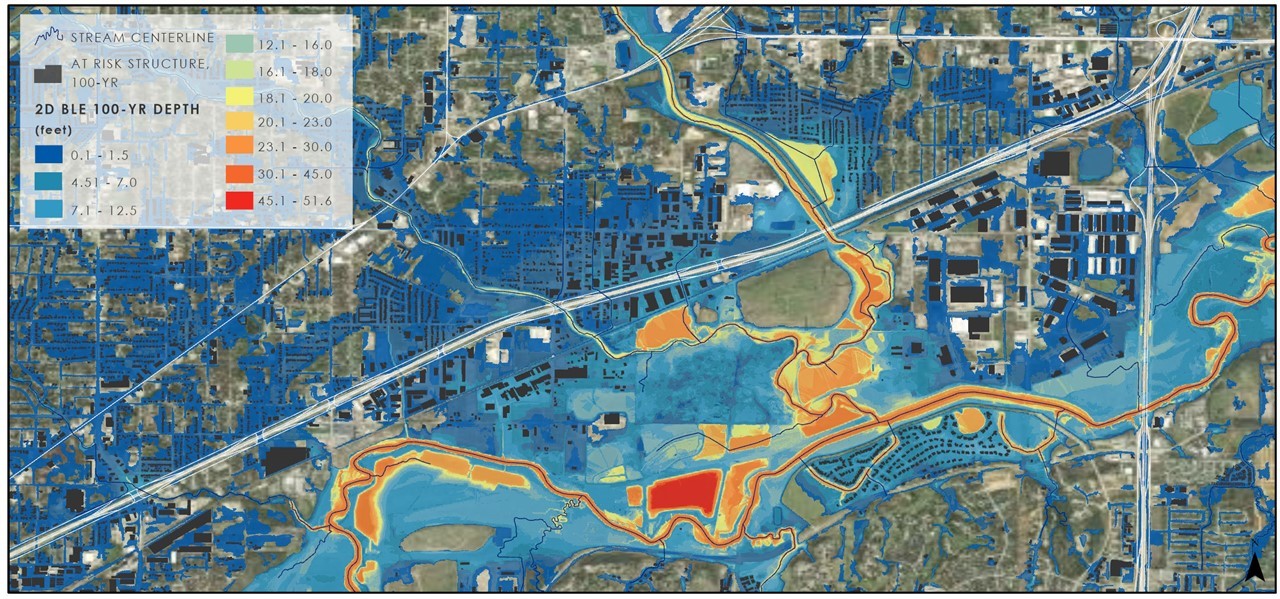
2D BLE produces not only floodplain extents but valuable depth grids, which offer a better understanding of flood risk as they show water depth relative to the ground.
The Statewide Base Level Engineering (BLE) project represents a groundbreaking, milestone initiative by the Texas Water Development Board (TWDB) in partnership with five vendors (Halff, AECOM, AtkinsRéalis, Freese and Nichols and Stantec).
Flood risk management is being transformed in Texas, as BLE’s data will help communities and authorities alike prepare for (and understand) flooding at a local and statewide level.
A Deluge of Flood Challenges in Texas
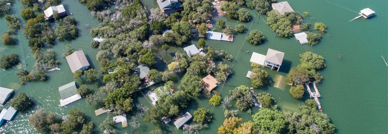
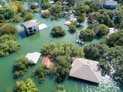
Flooding has a devastating impact to structures, such as these inundated homes in the Central Texas Region.
Texas is no stranger to the powerful natural phenomenon of flooding — a recurring challenge that tests the resilience of Texas communities every year.
Flooding historically ranks as one of the most frequent and costly natural hazards in Texas, with 72% of major disaster declarations resulting from severe weather, tropical storms, hurricanes or flooding. This natural phenomenon is deeply ingrained in the state’s diverse climate and geography, ranging from coastal plains to mountains and prairies.
From the 2015 torrential downpour along the Blanco River, to the Category 4 Hurricane Harvey in 2017, each flood highlights the urgent need for preparedness. Amid Texas’s growing population (one of the highest in the nation), the need for continued investment in flood hazard data remains paramount to safeguarding communities for resilient growth.
Bridging the Data Gap
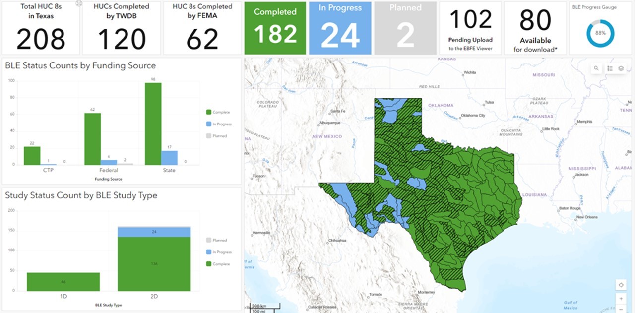
TWDB’s Base Level Engineering (BLE) Status Dashboard (image obtained Oct. 1, 2024) helps visualize and communicate real-time data of BLE progress.
This statewide BLE project addresses the urgent need for modernized and accessible flood risk data.
Accurate flood risk maps are considered vital tools for land use planning in flood-prone areas. FEMA’s Flood Insurance Rate Maps (FIRMs) have long been essential for determining flood insurance rates and helping communities manage development in flood-prone areas.
“Mitigation without proper mapping and coordinated planning may be ineffective, or worse—intensify flood impacts in upstream or downstream communities.” – 2019 State Flood Assessment
In 2019, Texas was still largely unaware of its full flood risk, with 31% of the state lacking floodplain maps and another 18% relying on outdated or incomplete maps. Recognizing this critical gap in flood risk data, the TWDB initiated statewide BLE using the latest technology and statewide lidar elevation data.
The complexity of the BLE project was no easy feat, given its vast scale and the coordination required among multiple agencies, including TWDB, FEMA and the U.S. Geological Survey (USGS). Ensuring consistency and integrity while delivering massive mapping datasets across Texas’s 268,000 square miles posed challenges.
A New Standard of Success for Communities
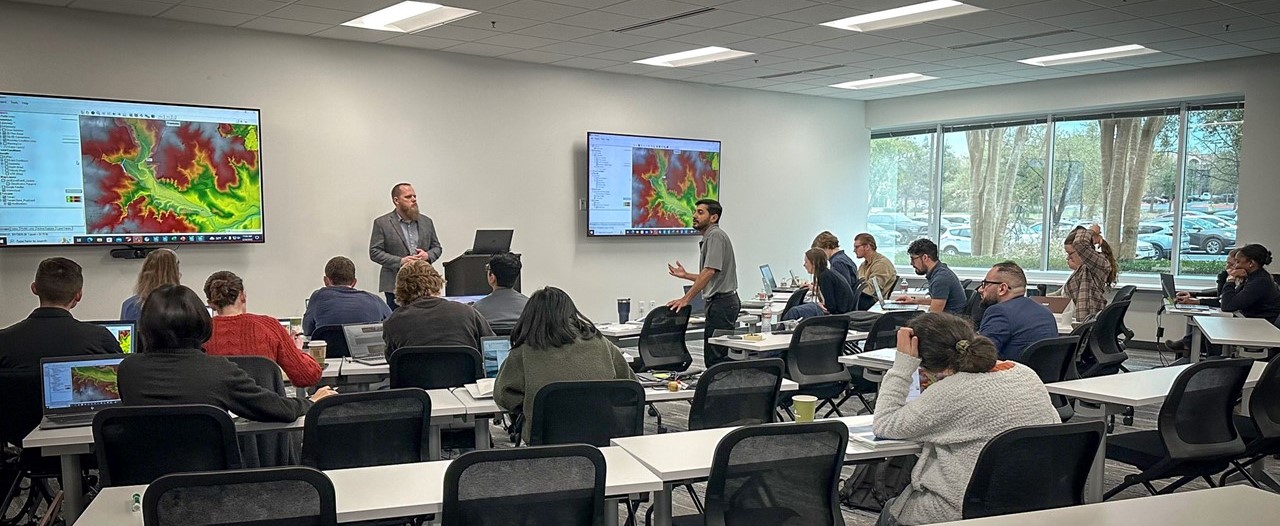
HEC-RAS 2D training courses teach individuals (including public officials and regulating authorities) how to observe, modify and review BLE models.
BLE is the missing piece that provides much-needed mapping, models and a variety of geospatial flood risk products that will help communities understand and manage flood risk moving forward.
The statewide BLE effort has resulted in a wealth of actionable data that will guide future development, enhance emergency response efforts and ultimately safeguard communities across the state. This accessibility is especially crucial for rural and underserved areas, ensuring that all communities alike can effectively manage their flood risk.
BLE’s application sets a new standard for flood risk management, also reducing the time and cost associated with traditional flood studies.
By utilizing LiDAR, advanced modeling software and GIS, BLE streamlined the flood modeling process for large-scale coverage at a fraction of the cost of traditional methods. BLE is particularly useful for areas that may not have had any flood mapping before.
All five of the vendors’ technical expertise, paired with the TWDB’s vision and collaboration with multiple agencies, has significantly advanced flood risk management in Texas.
Engineers using BLE are at the forefront of shaping the future of resilient, sustainable cities and infrastructure—adding lasting value to the engineering profession and society as a whole.
The future of flood risk management and community resilience is forever changed for the better, thanks to the Statewide BLE project in Texas.
Speak to our Water Resources team today! Our talented professionals bring years of flood risk mapping and management expertise and knowledge your communities need. Let Halff help you take the first step contacting Water Solutions Leader Cindy Engelhardt (cEngelhardt@halff.com).

Recent Stories
From Risk to Resilience: Halff’s Texas Flood Warning Systems in Action
Many communities in Texas’ Flash Flood Alley face frequent heavy rainfall and severe flooding. In the aftermath of the catastrophic…
Senior Project Manager Brad Bublitz Awarded Halff’s Home Run Award
Halff President and CEO Jessica Baker Daily (second from left) presents the Home Run Award to Brad Bublitz in Tavares,…